EDIFICE Inquiry - Map View
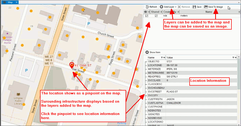
Use the Map view to see a geographical view of a location, connection and surrounding infrastructure. The location latitude and longitude are used to map the location as a pinpoint for a clear visual of the location and the connection(s). Clicking the pinpoint provides location information like book, sequence, and lot number will display on the lower right side of the screen. The coordinates typically are obtained from your town, city or utility. Maps can be overlaid with additional files added as layers that can provide asset information such as infrastructure like pipes, water mains and valves around the location. On the right side of the screen, you can see a list of files that can be added as a layer.
A map can be saved as an image that can be included on the location and if you use EDIFICE work orders, you can add the image to the work order.
Note: The Map view only shows if the feature is active. For assistance, place contact NDS Support at 800-649-7754.
From the EDIFICE Inquiry, click View and then click Map.
EDIFICE Inquiry - Map View Example:
EDIFICE Inquiry -Map View
|
|
Map Tools
A list of the layers available for the location displays below the tools. You can right-click on an location to save the map as an image. |
|
Refresh |
To refresh the view, click Refresh. |
Add Layer |
To add a layer to the map, click Add Layer. From the add layer screen, click the file name to add. |
Remove Layer |
To print a copy of the displayed image, click Print. |
Save |
|
Save to Image |
To save the image to a file, click Save to File. The following screen displays:
1. Navigate to the location where the image will be saved. 2. Enter a name for the image. 3. Choose a save file as type. 4. Click Save to save the image to the location. |

